Your cameras can be online, recording, and still produce unusable video. AI Image Analysis adds a new layer of health...

The future of urban life depends on our ability to build cities that are safer, cleaner, and more responsible. With social and economic inequities and climate hazards looming, this sounds like a daunting task. One possible solution? Smart cities.
With advances in technology and innovation, urban planning is taking on a new shape through the construction of smart cities – intuitive, responsive, and interconnected cities that are protecting citizens, improving quality of life, and decreasing harmful impacts on the environment.
Smart cities are supported by technology such as GIS mapping. Read on to better your understanding of the future of smart urban living and the critical role video security and GIS Mapping plays in it.
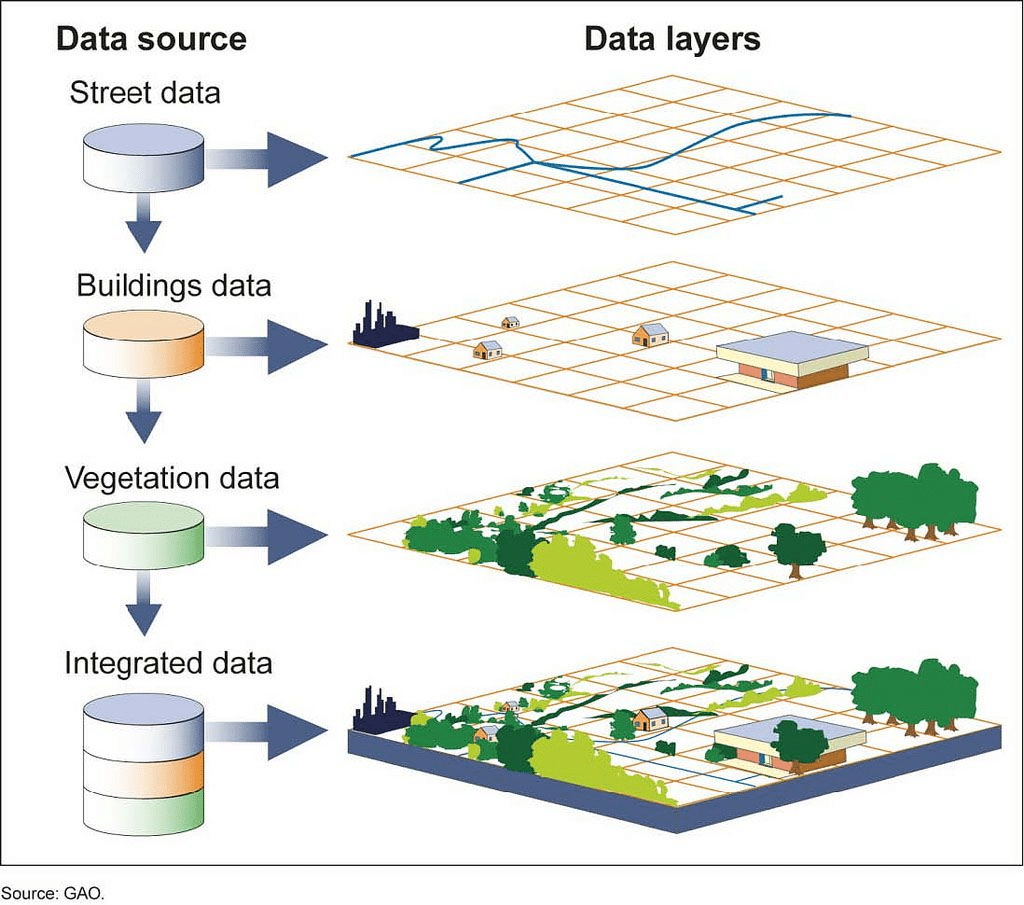
Smart cities are made possible by a technology called GIS mapping. “GIS” or Geographic Information Systems, is a system that creates, manages, analyzes, and maps a variety of data types.
GIS mapping plots data points on a map and uses the data to create visualizations of what’s happening, where, and when. In helping to identify routines, patterns, and unique relationships related to specific geographical data, GIS Mapping can help solve a wide range of challenges that cities might face.
Source: NatGeo
Mapping technology like GIS helps us better understand how major cities can operate more efficiently. Let’s explore some of the varied applications of GIS mapping and its implications – both positive and negative.
In large, developed cities like New York, Los Angeles, or Chicago, it’s nearly impossible to stay on top of every crime-related incident. Cities are expanding at a rate that is tough for security and law enforcement professionals to keep up with, especially by traditional means.
With GIS mapping, cities are immediately easier to understand, allowing for increased visibility and reduced oversight. Intelligent cameras and analytic tools with GIS mapping allow for more accessible video evidence and therefore, more resolved crimes. The same technology can be used to put preventative measures in place to better protect individual citizens, monitor private and public property, and save money down the line.
When it comes to emergencies, every second is valuable and could be the deciding factor between life and death. High-stress situations often require shortened, more efficient communication between parties, which leaves first responders in danger if they enter a situation with limited information.
In a smart city, video surveillance and GIS mapping give emergency responders the data they need to make prepared and informed response decisions, without sacrificing efficiency. The inherent interconnectedness in a smart city strengthens the collaboration between teams, granting easier communication, stronger situational awareness, and more in-depth data for future investigations or necessary reports.
For example, Live Earth is one of the most advanced geo-temporal data visualization platforms that connect millions of disparate data sources to provide real-time situational awareness across multiple industries. It’s even used by the Department of Defense!
In tourist areas that are ripe for large crowds, the risks of over-population, fire hazards, and potentially unsafe environments are more manageable with GIS mapping.
Through technologies ranging from digital signage to heat mapping and crowd counting, cities can manage crowds easier and more efficiently. An example of this is VENZO Secure Hybrid Series H400, which provides a platform for using video analytics to better wait times and therefore customer experiences.
As climate change continues to worsen and natural disasters become more frequent, tracking technology that uses geographic and climate data is one of our best defenses to keep communities safe.
Intuitive mapping technology has already been used in Patagonia to track environmental data and measure changes in ice structures and glaciers over time. With measurable geographic data that visualizes the real effects of climate change, GIS mapping is helping researchers to better understand how environments are changing.
In coastal cities and regions likely to be affected by climate disasters, mapping technology is being used to track hurricanes and better predict the impact they might have. It’s a life-saving technology that can help cities be better prepared to evacuate, build stronger infrastructure, and bounce back quicker in the coming decades.
One of the cornerstones of strong communities is the right to secure housing. Sadly, this isn’t the reality for millions of people across the country, and GIS mapping may offer a solution.
Mapping technologies can collect relevant data, such as local demographic and system performance patterns, to better understand the causes and determinants behind homelessness.
For example, mapped data such as demographic information and last permanent address can uncover commonalities in homeless populations and even reveal other micro factors contributing to housing insecurity.
In certain regions, GIS mapping has been implemented as a tool to educate citizens about potential COVID-19 exposure.
In a model developed for use in British Columbia neighborhoods, viewers can access mapping technology online that shows the spatial distribution of personal COVID-19 risk, based on factors such as:
This study would be useful for public officials to be able to understand the effectiveness of public health measures in high-risk areas. In addition, leveraging the combination of technology and data, viewers will also have access to make more informed decisions in an otherwise unprecedented time.
As video management experts who are immersed in the technology space, we know how important it is to consider the ethical implications of technology use.
Given the sensitivity of the data collected through GIS mapping, here are some questions we think are necessary to ask when it comes to implementing this technology in Smart Cities:
How is GIS data stored, for how long, and what is done with it afterward?
Who determines where surveillance technology is placed, and why?
Will surveillance be prioritized in more “dangerous” areas and therefore unknowingly target low-income communities?
As always, we fully support and adhere to “Milestone Systems’ Actions for Responsible Use, Data Privacy, and Human Rights”, and urge others adopting GIS mapping to do the same. Those who hold the power and capability to drive change with technology must also be equipped with tools to use it for good.

Your go-to XProtect eXPerts. We learn the technical stuff that will save you time and make it less boring.
Your go-to XProtect eXPerts. We learn the technical stuff that will save you time and make it less boring.
Your cameras can be online, recording, and still produce unusable video. AI Image Analysis adds a new layer of health...
If you're managing a large Milestone XProtect deployment, you already know the routine: camera checks, storage reports, compliance audits, and...

The Boring Lab’s Camera Hat campaign has been shortlisted for the Drum Marketing Awards Americas 2026 in the B2B category....